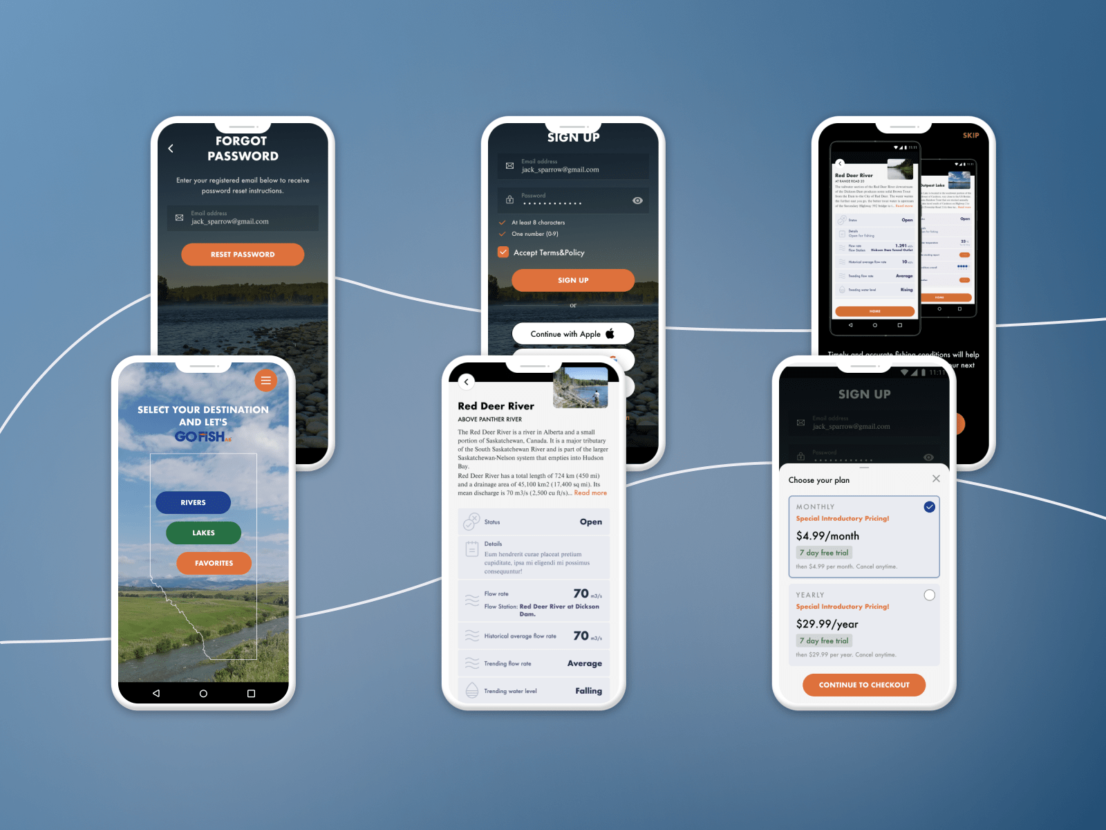
Our Services
GIS Solutions
We build GIS solutions that turn location data into actionable insights, with custom mapping, real-time tracking, and geospatial analytics.

Digitize your business with powerful, custom GIS software solutions. Build your own Geographical Information System (GIS) applications to capture, sort, and interpret your spatial and geographical information with a few clicks. It allows you to uncover critical insights from all your location data, map layers, and 3D models. Whether you need to integrate your apps with Google Maps, MapBox, Bing, ESRI ArcGIS or QGIS, we are confident to deliver the best for your business.
Why Choose This Service
Key Benefits
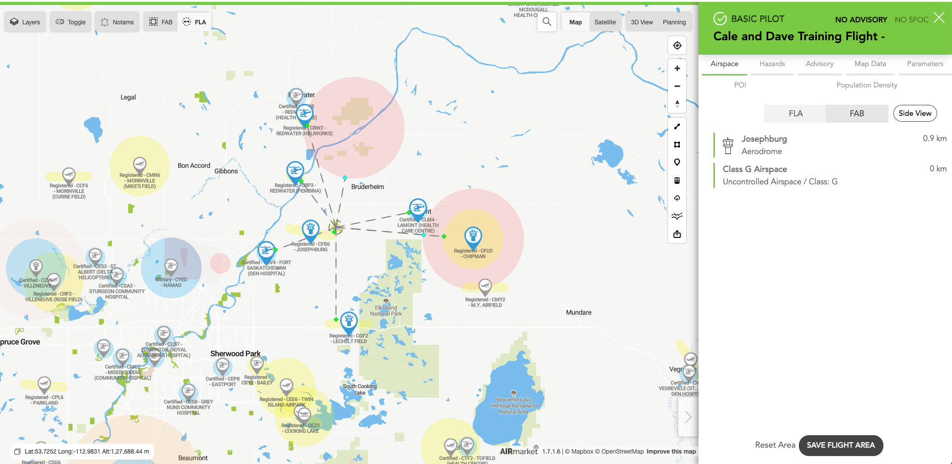
Build Beautiful Maps
Let us translate your data into interactive maps, tables, or graphs. We will accurately position and manage your spatial data, find geographical patterns, and offer GIS mapping solutions at an affordable cost.
Uncover Patterns and Trends
Monitor changes and respond to events promptly. A custom GIS application allows you to access an intuitive user interface that presents critical information to understand the interrelations of multiple layers of data at once.
Enable Better Decisions
With the most effective and efficient GIS apps at your fingertips, you are equipped with the capability to make informed decisions from your data through multiple ways to analyze spatial information.
GIS Mapping
Aveo Software has over 40 team experts ready to help you build industry-leading map solutions for your company.
GIS Reporting
We use only specialized and modern technologies to build the best GIS reporting and analytics applications for your business.
Custom GIS Implementation
From consulting and UX/UI design for GIS applications to custom implementation, count on our development team to help you bring your projects to life.
Capabilities
What's Included
Custom Map Development
Spatial Data Analysis
GPS Integration
Geofencing
Route Optimization
Real-time Tracking
3D Terrain Visualization
Drone & Satellite Data Processing
Our Work
Projects Built with GIS Solutions

Common Questions
Frequently Asked Questions
What is GIS?
A Geographic Information System (GIS) combines technology, data, and expertise to capture, sort, interpret, and present spatial and geographical information.
What is GIS app development?
GIS app development involves analyzing GIS-based process challenges and implementing application solutions that leverage spatial data and mapping technologies.
Why outsource GIS app development?
Outsourcing eliminates the cost of dedicated in-house hiring, provides access to specialized talent, and saves both time and money.
Why are GIS applications important for businesses?
GIS applications simplify processes, automate tasks, reduce operational costs, and improve overall efficiency and user satisfaction through spatial data insights.
How much does it cost to make a GIS application?
The cost varies based on scope, complexity, and features required. Contact us for a customized estimate based on your specific needs.
Ready to Get Started?
Let's discuss how our gis solutions expertise can accelerate your business.